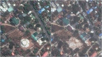
Before and after satellite images shows scale of devastation caused by Myanmar earthquake
A powerful 7.7-magnitude earthquake struck Myanmar on Friday, killing over 1,600 people.
The tremors were felt across Thailand and in nearby Chinese provinces.
It was the strongest earthquake to hit Myanmar in more than a century, according to the United States Geological Survey.
The disaster adds to the hardship in a country already battered by civil war and under military rule since 2021.
Rescue teams are still searching for survivors, while experts warn the full scale of the devastation could take weeks to assess.
Officials warned the death toll could rise as more information is gathered.
Satellite images show the extent of the damage.
Buildings in Mandalay, Myanmar
Remainings of the Ananda Pagoda and the Pindaya monastery in Mandalay, Myanmar
A collapsed Ma Shi Kha Na pagoda and surrounding buildings in Sagaing, Myanmar
The Mahamuni Pagoda and surrounding buildings in Mandalay, Myanmar
Overview of the collapsed Inwa Bridge over the Irrawaddy River in Mandalay, Myanmar
The fallen control tower of the Naypyitaw International Airport in Naypyitaw, Myanmar
Subscribe free to our weekly newsletter for exclusive and original coverage from ITV News. Direct to your inbox every Friday morning.
Want a quick and expert briefing on the biggest news stories? Listen to our latest podcasts to find out What You Need To Know...